
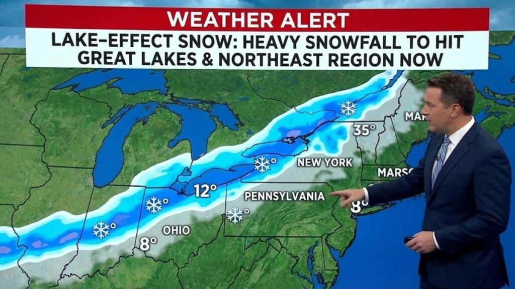
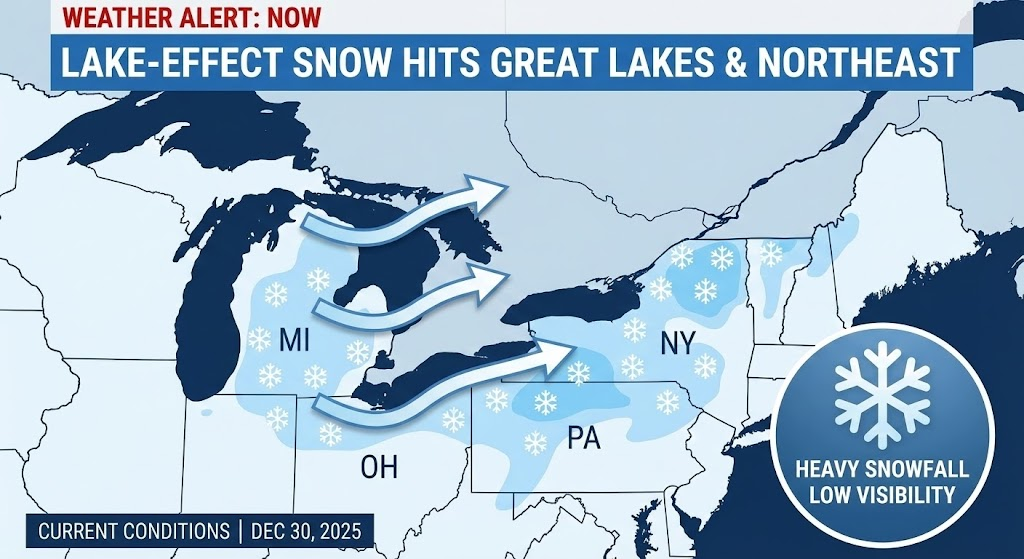
December 30, 2025 — As winter intensifies across the northern United States, meteorologists are spotlighting a powerful lake-effect snow phenomenon that is dumping heavy snow across communities surrounding the Great Lakes and stretching into parts of the Northeast. The Weather Channel’s latest coverage shows snow bands already intensifying over the region, with conditions expected to continue through the coming days as cold Arctic air interacts with relatively warm lake waters.
This year’s lake-effect snow events are part of broader winter storm activity in the region, which includes major systems like Winter Storm Ezra dragging snow, wind and ice from the Midwest to the Northeast, and persistent snow showers that are creating dangerous travel conditions and substantial accumulations.
What Is Lake-Effect Snow? The Weather Science Behind It
Lake-effect snow is a weather phenomenon that occurs when cold, dry air masses travel over the warmer waters of large lakes, such as the Great Lakes. As this colder air moves across warmer lake surfaces, it picks up heat and moisture from the water. This warmed, moist air becomes unstable and rises, cooling as it ascends and forming snow-producing clouds that then release heavy snowfall downwind of the lake.
This effect is most pronounced in late fall and early winter, when lake waters remain relatively warm but air temperatures drop sharply — a combination that provides the optimal temperature contrast for snow production.
The process can be summarised in a few key steps:
- Cold air moves over the warm lake surface — The colder the air and warmer the water, the more moisture is picked up.
- Air warms and becomes moist — As the air gains heat and moisture, instability increases.
- Snow clouds develop and grow — Rising moisture condenses into cloud bands called cloud streets.
- Snow falls downwind — Once the air mass moves over land again and cools further, the accumulated moisture falls as intense, localized snow.
Lake-effect snow often produces narrow bands of snow that can drop snow at rates of several inches per hour, leading to significant accumulations in localized areas, while nearby regions see much less snow.
Current Conditions and Storm Systems Fueling Snowfall
Meteorologists are currently tracking Winter Storm Ezra, which has already brought blizzard-like conditions through parts of the Midwest and Great Lakes and is now shifting snow, ice, and rain toward the Northeast. The system’s transition into a lake-effect snow event has raised concerns about heavy snow bands forming downwind of lakes and spreading inland in the coming days.
The Great Lakes region already saw robust lake-effect snow earlier in the season, with snow bands producing multi-foot totals in areas like upstate New York and Michigan’s snowbelt. Warm lake water combined with cold air moving down from Canada helped sustain these events.
Experts note that when a series of cold air masses continues to move over the lakes — particularly when the lakes are still unfrozen and above freezing — conditions are ripe for repeated rounds of heavy snow. Each cycle can leave behind deep snow accumulations, complicating commutes and straining local infrastructure.
Communities Most Affected
Lake-effect snow does not impact all areas equally — it largely depends on wind direction and the path air travels across open water. Locations that lie directly downwind of the Great Lakes — such as parts of western New York (including Buffalo), northern Pennsylvania, Michigan’s Lower and Upper Peninsulas, and parts of Ohio and Indiana — are historically among the hardest hit when the wind direction aligns right.
For example, a southwesterly wind blowing across Lake Erie and Lake Ontario can produce significant snow east and southeast of those lakes, dumping snow on places like Buffalo and areas of western New York.
Several smaller communities farther inland — such as those on the Tug Hill Plateau in New York — have some of the highest yearly snow totals anywhere in the country due to sustained lake-effect bands.
Snowfall Totals and Records
Lake-effect snow can be extreme. Records show that snowfall totals from multi-day lake-effect events can reach incredible levels — in some cases measured in feet rather than inches. For instance, certain bands that set up off Lake Ontario have produced over 100 inches of snow within a matter of days.
These intense snowstorms are not just occasional anomalies; they regularly dominate 24-hour snow rate records in the U.S., reporting large snow totals that far exceed what is typical in regular synoptic storms.
In more recent data, communities downwind of Lake Erie and Lake Ontario have reported snow depths exceeding 50 inches over the course of lake-effect events, with localized totals topping 65 inches or more in some spots.
Impacts on Travel, Infrastructure, and Daily Life
Lake-effect snow can cripple travel and municipal services if heavy bands persist for days. Roads can become snow-packed and slick, creating hazardous driving conditions, leading to traffic accidents, flight cancellations, and closed highways.
Local governments often deploy plow fleets, sand trucks, and emergency crews to keep major routes open, but persistent snowfall can quickly overwhelm snow-removal efforts, particularly in smaller towns with limited resources.
In addition to travel disruptions, heavy snow loads can threaten power lines and roofs, increasing the risk of outages or structural damage. Property owners may see snow drifts towering above doorways or require frequent shoveling to avoid buildup that can lead to collapse or injury.
Communities also endure economic impacts — from lost workdays due to unsafe conditions to disruptions in supply chains as trucking and freight movement slows.
Safety and Preparedness
Good preparation can mitigate many lake-effect snow hazards. Weather authorities typically issue lake-effect snow warnings and advisories when conditions are expected to produce heavy localized snow. Residents in these areas are encouraged to:
- Stay alert to advisories and closures.
- Limit travel during heavy snow bands and whiteout conditions.
- Have snow removal tools and emergency supplies ready.
- Ensure heating and insulation systems are functioning.
- Keep emergency kits in vehicles if travel is necessary.
Because lake-effect snow can be highly localized — with heavy snow in one town and light snow a few miles away — residents are urged to monitor local forecasts closely rather than rely solely on broad regional predictions.
Why 2025 Lake-Effect Snow Has Been Noteworthy
Several factors have contributed to a notable lake-effect snow season in 2025:
1. Warm Lake Water, Slow Ice Formation
Lake water retains heat longer than air. When lakes remain unfrozen later into winter, they provide more heat and moisture for storms. Last year, low ice coverage was linked to increased snow events because unfrozen lakes continued to fuel storms late into the season.
2. Strong Cold Air Intrusions
Cold air masses moving southward from Canada — often associated with larger winter storms like Winter Storm Ezra — help establish the conditions needed for lake effect bands to form.
3. Climatological Patterns
Climate patterns such as La Niña can influence jet stream behaviour, often bringing cold air into the northern U.S. and promoting more frequent lake-effect setups when combined with warm lake water.
Climate Change and Future Trends
Lake-effect snow’s relationship to climate change is complex. Some scientists argue that shifts in winter temperatures and ice cover patterns — which are linked to global warming — may initially lead to more intense lake-effect snow because lakes freeze later or less completely, allowing greater moisture transfer into the atmosphere.
However, over the long term, continued warming could reduce the duration of freezing air masses, shifting precipitation from snow to rain in some regions. This means the future of lake-effect snow could differ significantly from past decades — with more variability in where and how much snow falls.
Local Voices and Community Experiences
Across social media and local media coverage, residents of regions like western Michigan, western New York, and the snowbelt communities near Lake Erie describe lake-effect snow in everyday terms — heavy shoveling, house-buried cars, and the steady rhythm of snow plows. Some locals share humorous stories about clearing driveways for hours, while others talk about the challenge of commuting through narrow snow bands.
While sky-high snow totals can feel dramatic, many residents see lake-effect snow as part of winter life — one that binds communities together in shared experience. Yet when storms become extreme or prolonged, even those accustomed to snow take notice.
Looking Ahead: Forecast for Continued Snow in Northeast and Beyond
Forecast models indicate that as the current cold air mass persists and more lake moisture continues to be pumped into the atmosphere, additional snow bands could develop over the next several days — especially downwind of Lakes Erie and Ontario.
In some forecast scenarios, additional 1–3 feet of snow is possible in isolated locations, particularly where bands remain stationary for extended periods, while interior parts of the Northeast may see several more inches as systems move through.
Travelers and residents alike are being cautioned to plan for continued wintry conditions through at least the first week of January, when temperature fluctuations and synoptic changes may shift storm tracks.
Conclusion
Lake-effect snow is one of nature’s most striking examples of how local geography and atmospheric conditions combine to produce dramatic weather. This winter, as northern areas of the U.S. brace for more snow, strong winds, and lake-driven storms, the science remains the same — cold air over warm water generates snow bands that can bury towns in white, even as nearby areas stay relatively untouched.
Understanding how lake-effect snow forms and what drives it helps communities prepare, stay safe, and weather winter’s most intense snowfall events. With forecast models suggesting continued snow and hazardous travel conditions across the Great Lakes and Northeast, residents and travelers should stay informed and cautious as winter continues to unfold.
Pet trainer with a passion for helping animals and owners build strong, loving bonds through positive reinforcement and expert care.